

What Is a Landspout?
Among the dramatic weather phenomena observed worldwide, the landspout stands out as a unique and often misunderstood type of tornado. While most people associate tornadoes with massive supercell thunderstorms and widespread destruction, landspouts represent a distinct, and generally less hazardous category. Understanding landspouts is crucial not only for meteorologists, but also for the general public living in tornado-prone areas.
Defining Landspouts
A landspout is a type of tornado distinguished by its formation mechanism rather than its strength or visual characteristics. The term was coined by meteorologist Howard B. Bluestein in 1985 to refer to tornadoes forming from non-supercell thunderstorms—meaning they do not originate from intense, rotating storm systems known as supercells.
- Landspouts typically occur beneath thunderstorms lacking organized rotation (mesocyclones).
- They are often weaker than classic supercell tornadoes, though strong landspouts can occasionally cause damage.
- Although landspouts can be visually striking, they usually dissipate quickly and cover a smaller area than supercell tornadoes.
How Do Landspouts Form?
The formation of a landspout relies on the interaction of key atmospheric ingredients. Unlike supercell tornadoes, landspouts do not require powerful, organized rotation at cloud level. Here’s a step-by-step breakdown of the landspout formation process:
- Low-level wind shift: Near the ground, two different wind currents often meet, causing wind to shift direction—this region is known as a boundary.
- Horizontal wind shear: Along this boundary, low-level winds develop horizontal vorticity, which refers to small, invisible, tube-like eddies spinning horizontally.
- Thunderstorm updraft: As a thunderstorm’s updraft intensifies overhead, it can stretch these horizontal tubes vertically into the cloud.
- Tornado formation: When vertical stretching is sufficient, the horizontal vorticity tilts and becomes a vertical rotating column—the signature funnel of a landspout.
Unlike supercell tornadoes, which depend on a large-scale rotating storm (mesocyclone), landspouts develop solely from local boundaries and vertical stretching. They can form surprisingly quickly when conditions align, often within minutes.
Landspouts Versus Supercell Tornadoes
It’s important to understand how landspouts differ from the more widely known and dangerous supercell tornadoes. The following table summarizes the main distinctions:
| Feature | Landspout | Supercell Tornado |
|---|---|---|
| Formation | Non-supercell boundary, vertical stretching | From supercell, mesocyclone presence |
| Location | Beneath ordinary thunderstorms | Beneath supercell thunderstorms |
| Strength | Usually weaker, shorter-lived | Often strong, long-lasting |
| Warning Time | Minimal, often undetected | Advanced warnings possible |
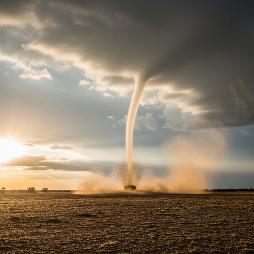
| Appearance | Narrow, rope-like or dusty funnel | Large, wedge-shaped funnel |
What Does a Landspout Look Like?
Landspouts may look deceptively similar to classic tornadoes, but several visual clues help distinguish them:
- Shape: Often appear as thin, rope-like funnels connecting the ground to the cloud base.
- Color: May appear dusty or brown near the base—due to picked-up soil—unlike the darker, broader funnels sometimes seen in supercell tornadoes.
- Size: Typically smaller and less imposing, with narrower funnels and less organized cloud structure.
- Movement: Can travel short distances quickly, but usually dissipate within minutes.
Despite frequently being weaker and shorter-lived, some landspouts have surprised onlookers with impressive visual structures or have caused minor damage to property and vegetation.
Where Do Landspouts Occur?
Landspouts are most common in regions with frequent thunderstorm development and ample surface boundaries. Some notable hotspots include:
- High Plains of the United States: Especially eastern Colorado, where dry lines and surface boundaries are prevalent.
- Central and western Kansas: Active thunderstorm alley—with numerous landspout sightings each year.
- Other locations: Anywhere with a combination of shallow boundaries and developing thunderstorms, including parts of Australia, South Africa, and Argentina.
Why Are Landspouts Often Missed?
Because landspouts generally form without the large, rotating structures that weather radar can identify in supercell storms, they are harder to forecast and spot ahead of time. Most landspouts are confirmed by visual observation or video, not by advanced Doppler radar detection—making them a challenge for meteorological monitoring and warnings.
Landspout Hazards and Safety
Even though landspouts are usually weaker than supercell tornadoes, they still pose real dangers:
- Wind damage: Capable of damaging roofs, windows, vehicles, and small structures.
- Flying debris: Loose objects, fencing, and vegetation may become airborne, risking injury.
- Agricultural impacts: Crops can be flattened or uprooted by intense winds near the core.
- Dust storms: In dry areas, landspouts can kick up sizable clouds of dust, reducing visibility.
Safety precautions during a landspout event mimic those recommended for any tornado incident:
- Seek shelter in a sturdy building away from windows and exterior walls.
- Move to the lowest floor or an interior room for best protection.
- Avoid driving during a landspout event, as sudden changes in wind direction and flying debris are hazardous.
Visual Examples of Landspouts
Although radar detection is limited, many landspout incidents are documented through photography and video. These examples highlight common visual form:
- Eastern Colorado: Landspouts often seen as thin, dusty columns moving rapidly across open fields.
- Kansas farmland: Narrow, rope-like funnels stirred up large amounts of soil and detritus.
For more information and visual documentation, weather enthusiasts and storm spotters regularly share landspout images with meteorological agencies and social media.
Why Do Meteorologists Care About Landspouts?
Landspouts, despite their relative weakness, are important for storm science because they:
- Provide insight into tornado formation outside of supercell environments.
- Challenge current weather forecasting tools, prompting new research into boundary detection and updraft mechanisms.
- Serve as cautionary reminders that tornadoes can occur in many thunderstorm regimes—not just the most severe.
Research into landspouts continues to advance, improving weather safety protocols and early warning systems in high-risk regions.
Frequently Asked Questions (FAQs)
Q: Are landspouts dangerous?
A: While most landspouts are less intense than supercell tornadoes, they can still cause property damage and injury, especially from flying debris and sudden wind gusts.
Q: How can I tell the difference between a landspout and a supercell tornado?
A: Landspouts often have thinner, less dramatic funnels and lack the organized storm structure seen in supercell tornadoes. They form under ordinary thunderstorms and can appear suddenly near visible surface boundaries.
Q: Can meteorologists predict landspouts?
A: Landspouts are harder to forecast than supercell tornadoes because they do not produce strong rotation detectable by weather radar. Meteorologists watch for boundary formation and severe thunderstorm development to estimate the likelihood of landspouts.
Q: What should I do if I see a landspout?
A: Follow standard tornado safety procedures: move indoors, avoid windows, seek shelter in an interior room, and stay tuned to official weather updates.
Q: Do landspouts occur over water?
A: While landspouts are a terrestrial phenomenon, their aquatic counterpart is the waterspout—formed by similar mechanisms but occurring over lakes or oceans.
Summary Table: Landspout Fast Facts
| Feature | Details |
|---|---|
| Type | Tornado, non-supercell |
| Formation | Boundary, low-level wind shift, updraft stretching |
| Strength | Typically weak, brief |
| Detection | Mainly visual, hard to forecast |
| Main regions | High Plains USA, Kansas, global thunderstorm-prone zones |
| Hazards | Flying debris, wind damage, dust storms |
Conclusion
Landspouts, once regarded as rare or insignificant, have become a vital aspect of severe weather science and public safety planning. By understanding their formation, recognizing their appearance, and following proper safety protocols, communities can respond effectively to these dynamic atmospheric events. For any region prone to thunderstorms, even weak or short-lived landspouts deserve respect and careful attention.
References
- https://www.youtube.com/watch?v=s_g8jHq7VT8
- https://www.treehuggerpod.com/episodes/local-oak-novela
- https://www.treehuggerpod.com/episodes/empty-lots
- https://tenstrands.org/how-can-you-be-a-tree-hugger-in-a-community-where-there-are-no-trees/
- https://open.spotify.com/show/1C1K2d5fZdqQDolXYo5iLP
- https://www.parksproject.us/blogs/in-park/10-ways-to-be-a-tree-hugger